Construction Projects
Oxford County undertakes projects year-round to improve roads, properties and infrastructure. This keeps our transportation network in good condition and supports the safe and efficient movement of people and goods in and through our communities.
With a number of major projects taking place in 2026, this page has been set up to make it easier for residents to get information about the current road reconstruction work.
Thank you for your patience while we work to make improvements to Oxford County roads and bridges this summer. Please remember to drive safely through construction zones.
Oxford County construction projects
Woodstock
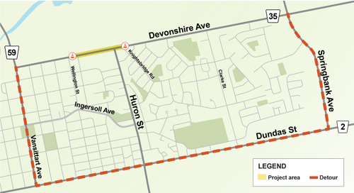 Oxford County is continuing a multi-year reconstruction project to improve Oxford Road 35 (Devonshire Avenue) in Woodstock. Phase 2 includes construction located just east of Wellington Street to just east of Knightsbridge Road.
During construction, this section of Devonshire Avenue will be closed in both directions and traffic will be limited to local residents, businesses and emergency services. Please note access to local businesses will be maintained as best as possible. A detour route will be in place for the duration of construction:
Detour: Vansittart Avenue, Dundas Street and Springbank Avenue
Construction work is tentatively scheduled to begin on April 7, 2026, and is expected to be completed by November 2026. Please note that construction schedules are weather dependent and subject to change based on site conditions, contractor availability and other operational demands.
Work will include:
- sanitary sewer, storm sewer and watermain replacement and repairs;
- road replacement with a three-lane cross section;
- bike lanes and sidewalks; and,
- traffic signal installation for a pedestrian crossing at Victoria Street.
Planned future phases will include a different section of Devonshire Avenue each year, extending east to Oxford Road 4, excluding the area between Lansdowne Avenue and Woodall Way.
Please help keep our community and workers safe: respect work zones, obey traffic signs, and maintain a safe distance from equipment and vehicles entering and leaving the site.
Previous phase
Phase 1 included Devonshire Avenue from Vansittart Avenue to Victoria Street North including the intersection of Vansittart Avenue and Devonshire Avenue. This phase was completed in 2025 and consisted of sanitary, storm and watermain replacement and repairs; road replacement with a three-lane cross section; bike lanes and sidewalks; and traffic signal and street light replacement.
 Oxford County is beginning road reconstruction work on Oxford Road 2 (Dundas Street) between Oxford Road 30 (11th Line) and Oxford Road 12 (Mill Street) in the City of Woodstock.
Oxford County is beginning road reconstruction work on Oxford Road 2 (Dundas Street) between Oxford Road 30 (11th Line) and Oxford Road 12 (Mill Street) in Woodstock.
Construction work is tentatively scheduled to begin on April 7 and is expected to be completed by November 2026. Work will take place in three (3) phases:
Phase 1: Oxford Road 2 (Dundas Street) from Oxford Road 30 (11th Line) and Oxford Road 9 (Ingersoll Road). Phase 1 is expected to be completed in summer 2026.
Phase 2A: Oxford Road 2 from Oxford Road 9 to west of Oxford Road 12.
Phase 2B: Intersection of Oxford Road 2 and Oxford Road 12. The intersection will be subject to a temporary four (4) week closure.
During construction, different sections of Oxford Road 2 will be closed between Oxford Road 30 and Oxford Road 12. Traffic will be limited to local residents, businesses and emergency services. A detour route will be in place for all three phases of construction:
Main detour: Oxford Road 30, Oxford Road 17 and Oxford Road 59 (Vansittart Avenue).
In addition to the detour noted above, detours will be in place during Phase 2A and 2B:
Phase 2A detour: Oxford Road 9, Main Street and Oxford Road 12.
Phase 2B detour: Oxford Road 9, Main Street and Oxford Road 59 (Wilson Street).
Work will include:
- Full road reconstruction including full watermain replacement and size upgrade, and select storm and sanitary replacement and size upgrade;
- Replacement of concrete curb, gutter and sidewalks;
- Improved northbound right turn lane at Oxford Road 9 and Oxford Road 2;
- Intersection improvements at Oxford Road 2 and Oxford Road 12;
- Addition of bike lanes;
- Additional traffic calming measures; and,
- Pedestrian crossing at the west end of Oxford Road 2, just east of the overhead rail bridge near Youth Start Trail.
Additional information
During Phase 1, traffic travelling north on Oxford Road 9 will have access to Oxford Road 2 travelling east (right turn). Traffic travelling west on Oxford Road 2 will have access to Oxford Road 9 travelling south (left turn). All other access will be limited to local residents, businesses and emergency services. Non-local traffic should use the main detour.
During Phase 2A, traffic travelling north on Oxford Road 9 will have access to Oxford Road 2 travelling west (left turn). Traffic travelling east on Oxford Road 2 will have access to Oxford Road 9 travelling south (right turn). All other access will be limited to local residents, businesses and emergency services. Non-local traffic should use the 2A detour.
 construction map") A section of the City of Woodstock’s Standard Tube, Burgess, and Rotary Club Millennium Trail along Oxford Road 30 (11th Line) is closed for work by Oxford County due to erosion between the roadway and trail.
A section of the City of Woodstock’s Standard Tube, Burgess, and Rotary Club Millennium Trail along Oxford Road 30 (11th Line) is closed for work by Oxford County due to erosion between the roadway and trail.
To stabilize the slope and prevent further erosion, design of a retaining wall and further embankment stabilization began in fall of 2024 with construction expected in 2026. This section of trail will remain closed until construction is complete.
To prepare for construction on the slope, Oxford County retained a tree clearing contractor to remove trees located within the slope failure area on Oxford Road 30. Tree clearing work was completed by March 31, 2025, to comply with requirements of the Migratory Bird Convention Act. In accordance with the City of Woodstock’s Tree Management Guidelines and upon completion of the slope work, roughly half of the removed trees will be replaced at a 3:1 ratio to support environmental sustainability. This work is essential to ensure safety and prevent further soil erosion in the area.
 Lansdowne Avenue (Township Road 3) will be closed from Halifax Road to Oxford Road 4, beginning late June until the end of August 2025 for sanitary sewer construction in support of the new pumping station under construction at 1074 Lansdowne Avenue. The work includes removing and replacing existing road makeup, ditch re-alignment, and improvements to local storm drainage.
Traffic will be limited to local residents, businesses and emergency services. A detour route will be in place for the duration of construction.
Detour: Lansdowne Avenue (Township Road 3), Devonshire Avenue (Oxford Road 35) and Oxford Road 4.
Construction of the sanitary pumping station began in January 2025 and is expected to be completed in March 2026.
Construction schedules are weather dependent and subject to change based on contractor availability and other operational demands.
To learn more about construction projects led by the City of Woodstock, visit the City's website.
Tillsonburg
Oxford County will begin work to install a backup generator at Wellhouses 4 and 5, located at 164164 Brownsville Road west of Tillsonburg, in September 2025. The two wellhouses are part of a critical network of 12 that supply drinking water to the Tillsonburg area.
The new back-up generator will help ensure Tillsonburg’s supply and demand needs for water can continue to be met as it experiences rapid growth. The project is scheduled for completion by December 2025.
 Construction of a new on-site water treatment facility at 445 Broadway Street is tentatively scheduled to begin early November 2025. The work includes demolition of the existing facility at 451 Broadway Street and site servicing improvements including watermain, sanitary sewer and storm sewer. This project is essential for enhancing the community’s water infrastructure, improving water quality, and ensuring long-term sustainability of the drinking water supply system.
Broadway Street will remain open to traffic during construction. Work will be limited to 445 and 451 Broadway Street, with access to the construction site maintained through the existing entrance on Christie Street.
Construction of the Well 7A water treatment facility is expected to be completed by December 2026. Construction schedules are weather dependent and subject to change based on contractor availability and other operational demands.
Update: Questions about arsenic removal process
Oxford County has received questions about the project's description on posted signage as an arsenic treatment project. Please be assured that drinking water in Tillsonburg remains safe and well within all provincial water quality standards. There is no risk to public health, and residents should continue to use their tap water as normal.
The Well 7A project is designed to bring a number of improvements to water treatment processes, including the installation of a dedicated filter to remove naturally occurring arsenic on site. This allows water to be supplied from this well independently to the Fairview treatment plant in future. Together, the improvements being made at the well will increase the amount of safe drinking water available to the community as a whole.
To download the annual drinking water system reports, visit www.oxfordcounty.ca/services-for-you/water-wastewater/drinking-water/annual-reports
If you have questions about this project, please contact:
Amy Grzywnowicz, P.Eng.
Project Engineer, Oxford County
519-539-9800, ext. 3223 | agrzywnowicz@oxfordcounty.ca
Visit the Water and Wastewater section of the website
The Town of Tillsonburg is undertaking road reconstruction on Cranberry Road, from North Street East at Tillson Avenue to the Town’s north limit.
Currently only 160 metres of Cranberry Road is serviced. This project, which is driven by growth opportunities, will extend water, sanitary and storm services by 640 metres on Cranberry Road to the Town limits. The project also includes roadway paving and the installation of sidewalks. During working hours, Cranberry Road will be reduced to one lane for local traffic but will reopen to two lanes during non-working hours.
Work along Cranberry Road began in early September to locate property services and begin removals. Work is expected to continue until December 2025 but will wrap up for the winter season. Work will resume in 2026 beginning in March and is expected to be complete by July 2026. Please note, construction schedules are weather dependent and subject to change based on contractor availability and other operational demands.
Public billing information call-in centre
A public information call-in-centre was held on Tuesday, November 25, 2025, to discuss the project billing for effected residents. If you missed the call-in-centre and would like more information, please download the resident notice below or contact the Public Works department at:
519-539-9800, ext. 3087
publicworks@oxfordcounty.ca
To learn more about construction projects led by the Town of Tillsonburg, visit the Town's website.
Ingersoll

Oxford Road 9 (Hamilton Road/King Street West), from CPKC Railway west to the Town of Ingersoll boundary and the intersection of Oxford Roads 9 and 10 (Ingersoll Street South), is expected to be closed to through traffic beginning as early as mid-March 2026 for infrastructure improvements. Construction will include relocating utilities; replacing sanitary sewer, watermain, curb and gutter; new traffic signals at Oxford Roads 9 and 10 and new street lighting; storm sewer improvements; sidewalk upgrades; and landscaping and restoration.
Sections of the Lawson Park trail will be closed beginning in January 2026 and are expected to reopen when construction is complete (see map below).
Construction will be carried out in two phases:
- Phase 1 – November 2025 to March 2026:Sanitary sewer installation by micro tunnel from a compound area south of Lawson Trail and northeast of the intersection of Oxford Road 9 and Oxford Road 10
- Phase 2 – March to December 2026: Sanitary, watermain and storm sewer; full road reconstruction; traffic signals; and final surface (asphalt) treatments
During Phase 2, Oxford Road 9 will be closed to through traffic. Traffic will be limited to local residents, businesses and emergency services. There will be a planned detour route in place for the duration of the road closure including applicable detour signage:
Detour: Oxford Road 10 (Ingersoll Street North), Road 60, Elgin Road and Hamilton Road
Please note that additional local detours routes may be in place at set periods during construction.
Road work is expected to be completed by December 2026. Please note, construction schedules are weather dependent and subject to change based on contractor availability and other factors.
Please help keep our community and workers safe: respect work zones, obey traffic signs, and maintain a safe distance from equipment and vehicles entering and leaving the site.
For more information, visit www.oxfordcounty.ca/IngersollOR9
Download the latest resident notice

To learn more about construction projects led by the Town of Ingersoll, visit the Town's website.
Blandford-Blenheim
East Zorra-Tavistock
Norwich
Oxford County is beginning bridge rehabilitation work on Oxford Road 59 (Stover Street South) bridge, located just south of Tidey Street in Norwich. The work includes full removal and replacement of the entire bridge superstructure, including the deck and girders (abutments to remain).
During construction, Oxford Road 59 from Front Street to Carman Street will be closed to all through traffic, as there will be no vehicle or pedestrian access to the bridge crossing for the duration of the project.
Construction work is tentatively scheduled to begin in early May 2026 and is expected to be completed in October 2026. Please note that construction schedules are weather dependent and subject to change based on site conditions, contractor availability and other factors.
Public Information Centre
A Public Information Centre (PIC) will be held to allow the public to view plans and discuss the project with Public Works Engineering staff and the consultant design team.
Thursday, April 16, 2026 | Drop in: 5:00 – 7:00 p.m.
Norwich Community Centre, 2nd Floor (Optimist Hall)
53 Stover Street South, Norwich
Additional information

During construction, Oxford Road 59 (Stover Street South) from Front Street to Carman Street, will be closed. Access between Main Street and Airport Road will be limited to local residents, businesses and emergency services as traffic will be unable to cross the bridge, located just south of Tidey Street, for the duration of construction.
Two detour routes will be in place for non-local traffic:
Detour 1: Northbound and southbound traffic will be detoured to Airport Road, Base Line and Norwich Road
Detour 2: Southbound traffic approaching easterly on Norwich Road will be detoured via Middletown Line and Airport Road
A detour route will be in place for pedestrians, cyclists and local traffic only:
Pedestrian/Cyclist detour: Carman Street, Pitcher Street and Main Street West
Oxford County is committed to working with the community to ensure access to local businesses is maintained throughout the construction period. If you are a business owner or operator with questions about access to your business at any time, please contact Public Works at 519-539-9800, ext. 3900, or publicworks@oxfordcounty.ca.
Please help keep our community and workers safe: respect work zones, obey traffic signs, and maintain a safe distance from equipment and vehicles entering and leaving the site.
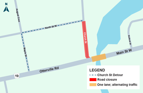 Oxford Road 19 (Otterville Road) between Church Street and Bullock Street in Otterville will be reduced to a single lane with alternating traffic controlled by traffic control signals for bridge rehabilitation work. The work includes full removal and replacement of the entire bridge structure including the deck and girders. Work is expected to be completed in two phases:
Phase 1: Construction on south side of structure; traffic alternating on the north side of the bridge.
Phase 2: Construction on north side of structure; traffic alternating on the south side of the bridge.
The south end of Church Street will be closed to serve as a construction staging area. Traffic will be limited to local residents, businesses and emergency services. A detour route will be in place for Church Street:
Detour: Maple Street and North Street West
Construction work is tentatively scheduled to begin in early April and is expected to be completed by December 2026. Please note, construction schedules are weather dependent and subject to change based on site conditions, contractor availability and other factors.
 Oxford County is beginning road reconstruction work on Oxford Road 59 (Church Street) from 150 metres west of Deer Crescent to 150 metres east of Smiths Lane in the Village of Burgessville in Norwich Township.
During construction, this section of Oxford Road 59 will be closed to through traffic and will be limited to local residents, businesses and emergency services for the duration of the project.
Construction work is tentatively scheduled to begin in May 2026 and is expected to be completed in December 2026. The work includes full road reconstruction, urbanization of the road cross section, and sidewalk and street lighting upgrades.
Public Information Centre
A Public Information Centre (PIC) will be held to allow the public to view plans and discuss the project with Public Works Engineering staff.
Thursday, April 30, 2026 | Drop in: 4:30 – 6:30 p.m.
Norwich Township municipal building, 285767 Airport Road, Norwich
Construction
During construction, this section of Oxford Road 59 will be closed to through traffic and will be limited to local residents, businesses and emergency services for the duration of the project. Construction will be completed in two phases with detour routes in place:
Phase 1
Oxford Road 59 (Church Street) will be closed to through traffic from the west limit of town to the east limit of town.
Phase 1 detours:
Northbound traffic: Oxford Road 40 and Oxford Road 14
Southbound traffic: Oxford Road 13 and Quaker Street
Phase 2
Oxford Road 59 will be closed from west of the Church Street and Main Street intersection to the west limit of town.
Phase 2 detours:
Northbound traffic: Main Street North/Middletown Line and Oxford Road 40
Southbound traffic: Oxford Road 13, Quaker Street, and Main Street South/Middletown Line
Please help keep our community and workers safe: respect work zones, obey traffic signs, and maintain a safe distance from equipment and vehicles entering and leaving the site.
South-West Oxford
Zorra
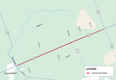
Culvert replacements will take place on Oxford Road 2 between Oxford Road 119 (19th Line) and Oxford Road 6 in the Township of Zorra. The work includes various culvert replacements, left-turn lane intersection work at 35th Line and restoration work as required. Culvert replacements will be completed through a combination of lane restrictions and road closures. Detours will be in place with applicable signage.
Construction is tentatively scheduled to begin in April and be completed by the end of May 2026. Please note that construction schedules are weather dependent and subject to change based on site conditions, contractor availability and other factors.
 Oxford County is beginning a multi-year project to complete upgrades to the Thamesford Wastewater Treatment Plant (WWTP) located at 10 Middleton Street in the Village of Thamesford.
Work includes the construction of a new two-storey headworks (screening) building, roof removal of the aeration tank, replacement of the facility generator, and installation of new process equipment. There is no impact expected to nearby residents or traffic.
This project will accommodate existing and future wastewater flow increases, and future development within Thamesford, ensuring long term regulatory compliance and sustainable operations.
Construction is expected to begin in May/June 2026 and will remain operational through construction and is expected to be complete in May 2028. Please note, construction schedules are weather dependent and subject to change based on site conditions, contractor availability and other factors.