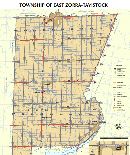
East Zorra-Tavistock
Application for Zone Change
Lot 7 & 8, Plan 80; Part Lot 9, Conc. 17 (East Zorra), Part 2 41R4441
91-95 Blandford Street
Application for Zone Change
Pt Lt 7, Conc. 16 (East Zorra)
715503 Oxford Road 4
Application for Consent and Zone Change
E 1/2 Lt 15, Conc. 12 (East Zorra) Lying E of Pt 7 OXR19
615899 13th Line
Applications for Official Plan Amendment, Draft Plan of Subdivision and Zone Change
Part Lot 10, Concession 17 (East Zorra), Part 1, 41R-9734
Southeast corner of Oxford Road 33 & 17th Line
Application for Consent
Pt Lt 18-19, Conc. 9 (East Zorra)
496131 10th Line
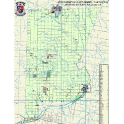
Township of East Zorra-Tavistock Zoning By-Law No. 2003-18
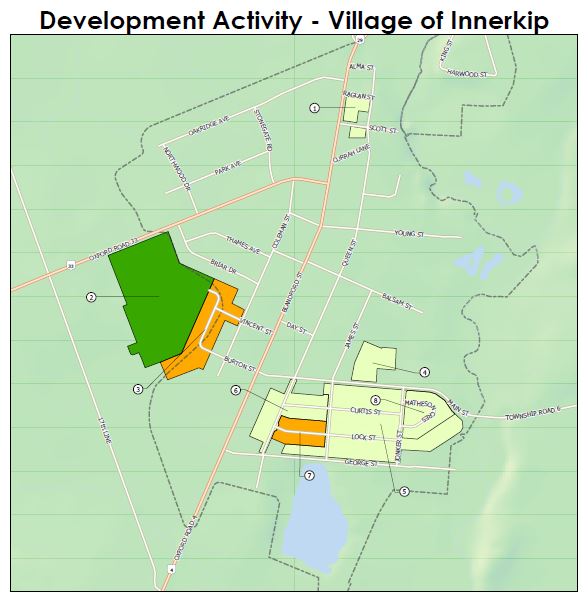
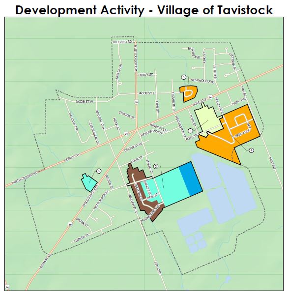
These maps show the status of residential subdivision development within the Area Municipality
The Township of East Zorra-Tavistock Zoning By-Law controls the use of land by dividing the municipality into different land use zones with detailed maps, specifying the uses permitted in each zone, specifying where buildings and other structures can be located, stating the types of buildings that are permitted and how they may be used, as well as specifying lot sizes and dimensions, parking requirements, building heights and setbacks from the street.
The contents of the Zoning By-Law reflect the latest consolidation of zoning by-law amendments, as of September 30, 2022. For up to date information on a specific property, please contact the Planner for the area municipality.
| Title | Description | Modified Date |
|---|---|---|
| Council Approved | A list of zoning bylaw amendments that have been approved by Council and are awaiting consolidation into the current bylaw. | 12/01/2022 |
| Final Approved | A list of all zoning bylaw amendments that have been consolidated into the current zoning bylaw. | 12/01/2022 |
| Application, Administration, Enforcement | Section 1 | 6/7/2021 |
| Interpretation | Section 2 | 6/7/2021 |
| Zones | Section 3 | 6/7/2021 |
| Definitions | Section 4 | 6/7/2021 |
| General Provisions | Section 5 | 6/7/2021 |
| Limited Agricultural (A1) | Section 6 | 6/7/2021 |
| General Agricultural (A2) | Section 7 | 12/01/2022 |
| Agri-Business (AB) | Section 8 | 6/7/2021 |
| Rural Residential (RR) | Section 9 | 12/01/2022 |
| Residential Existing Lot (RE) | Section 10 | 12/01/2022 |
| Estate Residential (ER) | Section 11 | 6/7/2021 |
| Residential Type 1 (R1) | Section 12 | 12/01/2022 |
| Residential Type 2 (R2) | Section 13 | 6/7/2021 |
| Residential Type 3 (R3) | Section 14 | 12/01/2022 |
| Village (V) | Section 15 | 6/7/2021 |
| Central Commercial (CC) | Section 16 | 6/7/2021 |
| Highway Commercial (HC) | Section 17 | 6/7/2021 |
| Restricted Industrial (MR) | Section 18 | 6/7/2021 |
| General Industrial (MG) | Section 19 | 6/7/2021 |
| Aggregate Industrial (ME) | Section 20 | 6/7/2021 |
| Development (D) | Section 21 | 6/7/2021 |
| Institutional (I) | Section 22 | 6/7/2021 |
| Recreational (REC) | Section 23 | 6/7/2021 |
| Open Space (OS) | Section 24 | 6/7/2021 |
| Approval | Section 25 | 6/29/2016 |
Schedules
| Title | Description |
|---|---|
| Key Maps | Schedule A |
| Parking Space Requirements | Schedules B-1, B-2 and B-3 |
Application Fees
Please check the current fee schedule prior to submission of your application.
Application Forms
Forms are available for the various types of development regulated by the Planning Act
Township of East Zorra-Tavistock Application Forms
- Zone Change
- Minor Variance - Committee of Adjustment
- Site Plan Control Guidelines
- Site Plan Control Application Form
Oxford County Woodland Conservation By-Law Form
Development Charges
County:
- Development Charges Fact Sheet (Effective June 13, 2026)
- Development Charges Interest Fact Sheet (Effective July 2026)
- Development Charges Annual Report - 2025
- Development Charge By-law - 6639-2024 (Passed June 12, 2024)
- 6709-2025 Development Charges By-law Amendment (Passed February 26, 2025)
Municipality:
Background study
At least every 10 years, Oxford County and area municipalities conduct development charges background studies to forecast future residential and non-residential growth to determine infrastructure needs and costs. This information is used to calculate the amount of money that new development needs to pay in order to cover the cost of new infrastructure and services.