Notice of Public Consultation Centre #2: Oxford Road 119 (Harris Street) and Clarke Road intersection improvements in Ingersoll
NOTICE OF PUBLIC CONSULTATION CENTRE #2
Oxford Road 119 (Harris Street) and Clarke Road intersection improvements in Ingersoll
Oxford County will be hosting a second Public Consultation Centre (PCC) for the Oxford Road 119 and Clarke Road intersection and Oxford Road 119 widening from Clarke Road to Highway 401 in Ingersoll
About this project
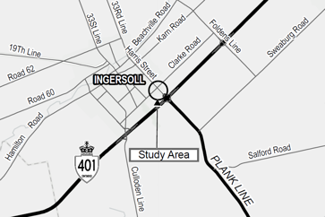 Oxford County is in the process of completing a Harmonized Class Environmental Assessment (Class EA) Study that will consider a range of alternative improvements to the Oxford Road 119 (Harris Street) and Clarke Road intersection, as well as the widening of Oxford Road 119 from Clarke Road to Highway 401 in the Town of Ingersoll (refer to the study area map).
Study process
This project is being completed as a Schedule “C” project in accordance with the Municipal Class Environmental Assessment (2024) and a Group “B” project under the Class EA for Provincial Transportation Facilities and Municipal Expressways (2024), approved under the Ontario Environmental Assessment Act.
Upon completion of this study, a Project File Report documenting the process will be submitted to the Ministry of the Environment, Conservation, and Parks and made available for public review for a period of 30 calendar days.
Public consultation
Public, Indigenous, and agency consultation is a key component of the Class EA process and will be sought throughout the study. Project information, study documents and updates are available on the project website on Speak Up, Oxford! at www.oxfordcounty.ca/speakup.
Oxford County will also be making study material and plans available for public review at a second Public Consultation Centre (PCC) in accordance with the Harmonized Class EA requirements. The PCC will be held at the following time and location:
Thursday, November 27, 2025
Drop in: 5:00 – 7:00 p.m.
Ingersoll Town Hall – Council Chamber
130 Oxford Street, 2nd Floor
The second PCC will present the results of the design alternatives and the recommended design, as well as provide an opportunity to review and comment on the proposed design.
If you would like to be placed on the mailing list to receive notices and information, or if you wish to provide comments at any time during the Class EA Study process, you can do so through the project contacts.
All comments received through the course of the study will be considered and documented in the Project File Report as part of the public record.
Contact
Noah Brister, P.Eng.
Project Engineer
Oxford County
nbrister@oxfordcounty.ca
519-539-9800, ext. 3107
Information will be collected in accordance with the Municipal Freedom of Information and Protection of Privacy Act. With the exception of personal information, all comments will become part of the public record.
This first notice issued October 24, 2025