


Nine new Community Safety Zones arriving in Oxford County in 2024
Oxford County is introducing nine new Community Safety Zones this spring.
The new proposed zones, which were decided through an eligibility and evaluation process, are located in:
- Ingersoll: Oxford Road 10 (Ingersoll Street North) from Bell Street to Victoria Street, and Oxford Road 119 (Bell Street) from Ingersoll Street North to Cashel Street
- Woodstock: Oxford Road 15 (Parkinson Road) from Mill Street to Norwich Avenue, and Oxford Road 35 (Devonshire Avenue) from Vansittart Avenue to Huron Street
- Tavistock: Oxford Road 24 (Hope Street West) from Woodstock Street to the 50 km/h limit West, and Hope Street East from Woodstock Street to the 50 km/h limit East
- Norwich: Oxford Road 18 (Main Street West) from Florence Street to Stover Street
- Tillsonburg: Oxford Road 20 (North Street East) from Broadway to Tillson Avenue
- Embro: Oxford Road 6 (Huron Street) from John Street to Halladay Street
Oxford County completed a review in 2022 of potential sites for Community Safety Zones, implementing the first 20 Community Safety Zones in the fall of 2023. County Council approved the nine additional Community Safety Zones at the February 14, 2024, Council meeting, bringing the total number of designated areas to 29 in Oxford County communities and segments of the County’s road network.
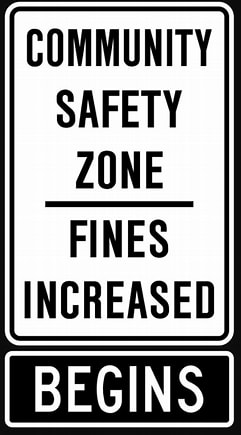
Community Safety Zones are designated areas where safety is of greater concern, for instance, near schools, community centres, recreation areas, playgrounds, hospitals, or seniors’ centres and residences. Marked by road signage, Community Safety Zones allow for increased fines for speeding and are also eligible for the potential future application of automated speed enforcement (photo radar).
Images
Contact Us